|
|
|
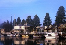 | |
The Wharf Area - at its peak in the 1850’s the port was the second busiest in Australia. Wool, wheat and gold were loaded onto great sailing ships bound for England.
Today, The Wharf is a wonderful place to relax and watch the world go by. The Norfolk pines and colonial buildings form a picturesque background to the tranquil waters of the Moyne River. An active fishing fleet still operates out of the harbour which is also home to a small fleet of pleasure craft. |
|
|
 | |
3 Sackville Street Port Fairy VIC
National Trust Building dating back to the 1840’s. Open 2-4pm Wednesday and Saturday |
|
|
| |
| There are over 50 buildings of significance and the best way to appreciate this legacy is on foot. Walking guides are available at the Visitor Centre. |
|
|
| | Battery Hill and the Powder Magazine |
|
| The hill first served as the Garbour Master’s signal point for shipping. Local militia units established the gun batteries and built the concrete fortifications that were completed in 1857. The collection of such weapons is exceptional. The bluestone powder magazine was built in 1860 to store explosives used in construction of the river wall. |
|
|
| |
| Fascinating island to the west of Port Fairy. Australia’s only submarine volcano, the lava flows have created an unusual flat top and almost vertical cliffs surround the island. Home to the largest fur seal colony in the southern hemisphere - you are able to book a boat trip from the wharf (subject to weather). |
|
|
| | Short Drives - Yambuk (15 minutes 17 kilometres West) |
|
| Small settlement on the Shaw River. Yambuk Lake and wetlands are formed by the natural damming of the Eumeralla and Shaw Rivers behind the massive sand dunes in the area. Good fishing, boating and walking. Haven for bird, animal and plant life. Historic Hotel dating back to the 1850’s. |
|
|
| | Short Drives - Codrington Settlement & Gardens |
|
4887 Princes Highway Codrington VIC
(23 kilometres West of Port Fairy)
Licensed Restaurant open Thursday to Sunday 10-4. Antiques, local artists works, 3 acres of gardens. |
|
|
| |
The most popular beaches for swimming are the East Beach and Pea Soup Cove. The local surf lifesaving club patrols East Beach during peak times (always swim between the flags).
East Beach offers excellent surfing breaks, for beginners through to advanced, also popular for kite surfing. |
|
|
| |
Located on the Princes Highway between Warrnambool and Port Fairy.
Discover ancient volcanic land formations, wildlife, aboriginal culture. Guided walks with Worn Gundidji’s experienced team. Contact Information Centre for further details. |
|
|
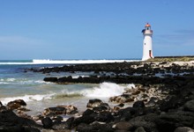 | |
| Situated on Griffiths Island and constructed from local bluestone by Scottish stonemasons in 1859. The keepers cottages were demolished in the 1950’s but the lighthouse still operates on wind and solar power. The light is visible 19 kilometres out to sea. |
|
|